
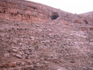
Location – Coordinates of the main excavation area in the northern branch of the Isimila Korongo are 7o53″48’S and 35o36″12’E (Howell et al. 1962, 45). The East African Archaeological Grid reference is Hx Jg (Cole and Kleindienst 1974). The site is situated 21 km (13 miles) from the town of Iringa in the southern highlands of Tanzania. Elevation above Sea Level – About 1631 m (Howell et al. 1962).
History of Research – D. A. Maclennan (South Africa) discovered the site in 1951 during a car journey from Nairobi to Johannesburg. F. C. Howell, M. R. Kleindienst and G. C. Cole excavated the site for a total of 7 months during 1957–58 (Howell et al. 1962, 44). An additional season of excavation, directed by Hansen and Keller, took place in 1969 (Hansen and Keller 1971), and a small-scale excavation was undertaken by Kleindienst in 1970.
Excavated Area – The exact surface area of the excavation in 1957–58, encompassing all its numerous excavation spots, trenches and sounding pits, has not been published. During the 1969 excavation, an area of 620 m2 was opened in grid unit K13 (Hansen and Keller 1971). The 1970 small-scale excavation was conducted in the Sand 4 layers.